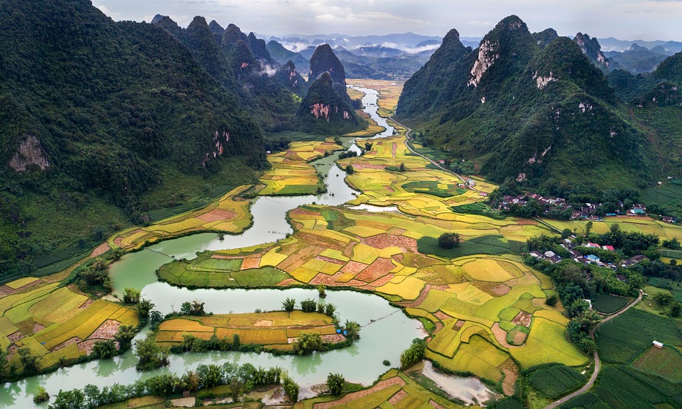
A watershed is a channel (stream, river) that concentrates runoff (water) to the main discharge point (a large body of water). Usually, the discharge point is at the lowest point in the watershed.
Headwaters are the beginning of a watershed. Watersheds are typically separated by ridges or mountains that form the highest part of the watershed. From here, runoff moves to lower elevations forming streams and rivers.
These streams and rivers can diverge and create sub-watersheds, but all of the runoff discharges into one point, a lake or ocean.

Characteristics of A Watershed
The characteristics of a watershed, like size, length, slope, rate, and present plant life, impact its production and efficiency.
- The size (area) of a watershed can be a reflection of the amount of runoff and what is created by the runoff, i.e. river, stream, or creek. It could also reflect how the runoff is discharged, i.e. the ocean or lake. It also plays a role in how much runoff can be held in the watershed.
- The length and slope of a watershed play a big factor in the runoff rate.
- Runoff is increased by steeper slopes that allow water to flow downwards with the help of gravity.
- The length of a watershed is the distance between the headwaters and the discharge point. This mainly impacts how long it takes for runoff to reach the discharge point. Hence, the longer the watershed, the longer it would take for runoff to be discharged.
- The type of soil found in watershed impacts the amount of runoff absorbed by soil as well as the vegetation. If the soil is very sandy or has large particles, the soil will take in more runoff water. In addition, if the soil is fertile, there will be more vegetation. Finally, soil can play a role in filtering water in a watershed.
- Vegetation plays an important role in soil erosion. The more plants in a watershed, the lesser amount of erosion that will take place. Vegetation can also improve soil fertility and water filtration.
🎥 Watch: AP Environmental Science Streams
Frequently Asked Questions
What is a watershed and how does it actually work?
A watershed is all the land that drains rainwater and snowmelt to a single outlet (stream, lake, or ocean). It’s defined by drainage divides (high ridges) and includes headwaters, tributary networks, and the basin area. How it works: precipitation either infiltrates the soil or becomes surface runoff; soil infiltration rate, permeability, slope, vegetation, and impervious cover (roads, roofs) control that balance. Steeper slopes and more impervious surface → faster runoff, higher peak flows and erosion; higher infiltration and riparian buffers slow flow, filter pollutants, and recharge groundwater. Drainage density, basin morphology, and Strahler stream order describe how connected and developed the network is. For APES, you should be able to describe watershed area, divides, slope, soil type, vegetation, and how land use affects runoff and water quality (CED ERT-4.F.1). For a quick topic review see the Watersheds study guide (https://library.fiveable.me/ap-environmental-science/unit-4/watersheds/study-guide/5ZXbQ58u1JOTlYRgbea0) and more Unit 4 resources (https://library.fiveable.me/ap-environmental-science/unit-4). Practice questions available at (https://library.fiveable.me/practice/ap-environmental-science).
Why do watersheds matter for the environment?
Watersheds matter because they connect everything upslope to streams, rivers, wetlands, and people downstream. Characteristics like watershed area, slope, soil infiltration rate, vegetation (riparian buffers), impervious surface cover, and drainage divides control how much water runs off versus soaks in, how fast it flows (drainage density, Strahler stream order), and how much sediment, nutrients, or pollutants reach aquatic ecosystems. That affects water quality, flood risk, habitat for fish and other species, nutrient cycling, and groundwater recharge. Human land cover changes (more pavement, less vegetation) increase runoff, erosion, and pollutant loads—so managing riparian buffers and land use in a watershed reduces floods and improves ecosystem and human health. For APES, you should be able to describe watershed features per ERT-4.F and explain links to water quality and land use (see the Topic 4.6 study guide for a quick review: https://library.fiveable.me/ap-environmental-science/unit-4/watersheds/study-guide/5ZXbQ58u1JOTlYRgbea0). For broader review and practice, check Unit 4 (https://library.fiveable.me/ap-environmental-science/unit-4) and practice problems (https://library.fiveable.me/practice/ap-environmental-science).
What's the difference between a watershed and a river basin?
A watershed and a river basin are related but not identical. A watershed is the smaller unit: the land area that drains surface water to a single outlet (stream, lake, or wetland). Its defining features are area, headwaters, stream network (Strahler order), slope, soil infiltration/permeability, vegetation, riparian buffers, and drainage divides with neighboring watersheds (CED ERT-4.F.1 keywords). A river basin is larger—it’s the whole network of linked watersheds that drain into a major river and its outlet (e.g., the Mississippi Basin contains many individual watersheds). For APES you should be able to describe watershed characteristics (area, divides, drainage density) and how land cover or impervious surfaces change runoff and water quality—common MC/FR topics in Topic 4.6. For a quick review, see the Topic 4.6 study guide (https://library.fiveable.me/ap-environmental-science/unit-4/watersheds/study-guide/5ZXbQ58u1JOTlYRgbea0) and more Unit 4 resources (https://library.fiveable.me/ap-environmental-science/unit-4).
I'm confused about watershed divides - can someone explain what they are?
A watershed divide (aka a drainage divide) is the high ground—a ridge, hilltop, or elevation line—that forms the boundary between two adjacent watersheds. Rainfall on one side of the divide flows into that watershed’s headwaters and tributary network; rainfall on the other side flows into the neighboring basin. Divides control the watershed area, drainage density, and where pollutants or nutrients travel, so they’re key when you describe a watershed’s characteristics (area, length, slope, soil, vegetation, and divides) for ERT-4.F on the CED. Divides can be obvious (mountain ridges) or subtle (low slopes) and can shift over time with erosion or human changes (roads, urbanization, channelization). Knowing divides helps with land-use planning, riparian buffers, and source-water protection. For a short review, see the Topic 4.6 Watersheds study guide (https://library.fiveable.me/ap-environmental-science/unit-4/watersheds/study-guide/5ZXbQ58u1JOTlYRgbea0). For broader Unit 4 review and practice, check the unit page (https://library.fiveable.me/ap-environmental-science/unit-4) and practice problems (https://library.fiveable.me/practice/ap-environmental-science).
How do you determine the boundaries of a watershed?
Find the outlet first (where the stream leaves the area). From that point, trace uphill following ridgelines and high ground—these ridgelines are the drainage divides that separate one watershed from adjacent ones. On topographic maps, follow contour lines: the watershed boundary always runs along the highest contours between adjacent streams. On digital elevation models or GIS, use flow-direction/accumulation tools to map the tributary network and delineate the basin automatically. Measure area, main channel length, average slope, and drainage density once the boundary’s set; you can also assign Strahler stream orders to tributaries. Soil, vegetation, and impervious cover inside the boundary determine infiltration and runoff. This process matches CED keywords (drainage divide, headwaters, tributary network, watershed area, slope). For a quick review, check the Topic 4.6 study guide (https://library.fiveable.me/ap-environmental-science/unit-4/watersheds/study-guide/5ZXbQ58u1JOTlYRgbea0). For more unit review and practice, see the Unit 4 page (https://library.fiveable.me/ap-environmental-science/unit-4) and practice problems (https://library.fiveable.me/practice/ap-environmental-science).
What are the main characteristics that define a watershed?
A watershed is any land area that drains water to a common outlet (stream, lake, or ocean). Key characteristics you should be able to describe for APES (ERT-4.F) are: area (total basin size), drainage divides (boundaries separating adjoining watersheds), headwaters (source streams), and the tributary network including Strahler stream order and drainage density. Physical attributes matter: watershed length, slope (affects runoff speed), basin morphology and stream channel length. Soil properties—permeability, infiltration rate, texture—and land cover (vegetation types, riparian buffers, and percent impervious surface) control how much water runs off vs. infiltrates. These traits determine flooding, erosion, pollutant transport, and habitat quality. On the exam you may be asked to describe or compare these features, so know the keywords above and practice applying them to maps and graphs. For a quick review use the Topic 4.6 study guide (https://library.fiveable.me/ap-environmental-science/unit-4/watersheds/study-guide/5ZXbQ58u1JOTlYRgbea0), the Unit 4 overview (https://library.fiveable.me/ap-environmental-science/unit-4), and practice questions (https://library.fiveable.me/practice/ap-environmental-science).
Why does the slope of a watershed affect water flow and pollution?
Slope controls how fast water moves across a watershed. Steeper slopes create faster surface runoff, reduce infiltration rate, and increase erosion and sediment transport—so more soil, nutrients (like N and P), and pollutants reach streams quickly. Gentle slopes slow flow, allow more infiltration and filtering by soil and riparian buffers, and lower peak discharge. On steep, urbanized slopes with high impervious surface cover, runoff and pollutant pulses are especially large because water can’t soak in. For APES, link this to watershed characteristics (slope, soil permeability, vegetation, riparian buffer) and to problems like increased turbidity, eutrophication, and downstream flooding—common free-response topics in Unit 4 (Earth Systems and Resources). Review the Topic 4.6 study guide for concise examples (https://library.fiveable.me/ap-environmental-science/unit-4/watersheds/study-guide/5ZXbQ58u1JOTlYRgbea0), and practice related problems at (https://library.fiveable.me/practice/ap-environmental-science).
How does vegetation in a watershed impact water quality?
Vegetation in a watershed strongly controls water quality by affecting runoff, infiltration, erosion, and nutrient cycling—all characteristics you need to know for ERT-4.F on the AP exam. Plants (especially riparian buffers) stabilize stream banks, reducing sediment input and turbidity. Roots increase soil permeability and infiltration rate, which lowers surface runoff and the transport of pollutants into streams. Vegetation also uptakes and filters nutrients (N, P) and some contaminants, reducing eutrophication downstream. Removing vegetation or replacing it with impervious surfaces increases runoff, erosion, and pollutant loads and raises drainage density and channel instability. On the exam, mention vegetation type, riparian buffer function, soil infiltration rate, and impervious surface cover when describing a watershed’s impact on water quality (Topic 4.6). For a focused study, see the Topic 4.6 study guide (https://library.fiveable.me/ap-environmental-science/unit-4/watersheds/study-guide/5ZXbQ58u1JOTlYRgbea0), the Unit 4 overview (https://library.fiveable.me/ap-environmental-science/unit-4), and practice questions (https://library.fiveable.me/practice/ap-environmental-science).
What happens when soil types are different across a watershed?
Different soil types across a watershed change how water moves, where it’s stored, and what reaches the stream. Permeable, sandy soils = high infiltration and groundwater recharge, lower surface runoff and peak flows; clayey or compacted soils = low infiltration, more overland flow, higher erosion and sediment/nutrient loading. That affects drainage density, stream discharge timing, riparian vegetation, and water quality (more turbidity and nutrient runoff where soils erode). It also changes watershed slope effects—steep areas with thin soils produce quick runoff; flat areas with deep, permeable soils store more water. On the AP exam you might be asked to describe these watershed characteristics (ERT-4.F) or predict runoff/erosion based on soil infiltration/permeability. For a quick review on watershed terms and how soil interacts with streams, check the Topic 4.6 study guide (https://library.fiveable.me/ap-environmental-science/unit-4/watersheds/study-guide/5ZXbQ58u1JOTlYRgbea0). For extra practice, try problems at (https://library.fiveable.me/practice/ap-environmental-science).
I don't understand how watershed length affects anything - why does it matter?
Watershed length matters because it changes how water and stuff move through the basin. Longer stream-channel length usually means water takes longer to travel (higher time-of-concentration), so floods are slower but can last longer. Length also affects stream velocity, erosion, and sediment transport: longer, steeper channels increase erosion and downstream sediment load. It changes drainage density and Strahler stream order (more/longer tributaries raise order), which influence habitat complexity and pollutant dilution/transport—pollutants travel farther and persist differently in long basins. For APES, this ties directly to ERT-4.F.1 (watershed characteristics: length, area, slope, channel length) and appears in questions asking you to describe or explain watershed behavior on the exam. Want a quick review or practice problems on this? Check the Topic 4.6 study guide (https://library.fiveable.me/ap-environmental-science/unit-4/watersheds/study-guide/5ZXbQ58u1JOTlYRgbea0) and try practice sets at (https://library.fiveable.me/practice/ap-environmental-science).
How do adjoining watersheds connect or separate from each other?
Adjoining watersheds are separated by drainage divides—ridges or high ground that direct surface runoff into different basin networks. A divide is the watershed boundary: precipitation on one side flows to that watershed’s headwaters and tributary network, on the other side it flows elsewhere. They can connect, though: low or subtle divides, wetlands, flood events, or man-made channels (canals, storm drains) let surface water cross boundaries. Subsurface connection is also common—shared aquifers or high soil permeability can move groundwater between basins even when surface divides look distinct. Riparian buffers, land cover, and watershed slope/soil infiltration rates influence whether overflow happens and how quickly waters mix. On the APES exam you might be asked to describe divides and these connections (CED ERT-4.F—watershed divides with adjoining watersheds). For a quick refresher, see the Topic 4.6 study guide (https://library.fiveable.me/ap-environmental-science/unit-4/watersheds/study-guide/5ZXbQ58u1JOTlYRgbea0) and practice problems (https://library.fiveable.me/practice/ap-environmental-science).
Why do we need to study watershed characteristics for the AP exam?
You need to study watershed characteristics because they’re a core CED topic (ERT-4.F) that shows up on both multiple-choice and free-response questions in Unit 4 (Unit weighting: 10–15%). Watershed features—area, length, slope, soil infiltration/permeability, vegetation/riparian buffers, drainage divides, tributary networks, Strahler stream order, and impervious cover—determine runoff, erosion, water quality, and pollutant transport. AP questions often use maps, models, or data sets (Practice 2 and 5) to ask you to describe, analyze, or propose solutions (free-response skills). Knowing those keywords helps you explain why a watershed with steep slopes and high impervious surface increases runoff and pollution, or why riparian buffers reduce sediment and nutrient loading. Review the Topic 4.6 study guide for focused examples and practice (https://library.fiveable.me/ap-environmental-science/unit-4/watersheds/study-guide/5ZXbQ58u1JOTlYRgbea0), and use the Unit 4 overview and Fiveable practice problems for extra question practice (https://library.fiveable.me/ap-environmental-science/unit-4; https://library.fiveable.me/practice/ap-environmental-science).
What's the relationship between watershed area and the amount of water it can hold?
Bigger watershed area usually means more water can be collected and routed into streams and the basin—but it’s not just size that controls how much water it “holds.” A larger area intercepts more precipitation and feeds a bigger tributary network (higher total discharge potential), so peak streamflow and total runoff tend to increase with area. However, watershed slope, soil infiltration rate/permeability, vegetation (riparian buffers), and impervious surface cover strongly modify that relationship: steep, paved, or bare watersheds generate more rapid runoff and higher peaks, while flat, vegetated, high-permeability watersheds infiltrate more and store more water in soil and groundwater. For APES, describe area alongside drainage density, stream order, slope, soil/land cover, and divides—those are the CED keywords you’ll be tested on (see the Topic 4.6 study guide: https://library.fiveable.me/ap-environmental-science/unit-4/watersheds/study-guide/5ZXbQ58u1JOTlYRgbea0). For free-response, connect area to runoff volume and to management solutions (e.g., increase riparian buffers or reduce impervious surfaces) when justifying impacts or solutions.
How does human development change watershed characteristics?
Human development changes watershed characteristics in predictable ways. Replacing vegetation and soil with roads, roofs, and parking lots increases impervious surface cover, which lowers soil infiltration and groundwater recharge and raises surface runoff and peak stream flows—causing greater erosion, higher drainage density, and channel incision. Removing riparian buffers and filling wetlands reduces filtration of sediments and nutrients, so pollutant loads (sediment, N, P, heavy metals) and water temperature rise. Grading and development change watershed slope and basin morphology, which alters stream length and can change Strahler stream order locally by diverting or burying tributaries. Overall, you get flashier hydrographs, reduced baseflow during dry periods, habitat loss, and more frequent flooding. These are all watershed characteristics listed in the CED (area, slope, soil, vegetation, divides, impervious cover, infiltration rate, riparian buffer) and are fair game on AP questions (ERT-4.F). For a focused review, check the Topic 4.6 study guide (https://library.fiveable.me/ap-environmental-science/unit-4/watersheds/study-guide/5ZXbQ58u1JOTlYRgbea0) and more Unit 4 resources (https://library.fiveable.me/ap-environmental-science/unit-4). Practice problems: (https://library.fiveable.me/practice/ap-environmental-science).
Can you explain how to identify watershed divides on a topographic map?
Look for the ridgeline that separates where water flows into different stream networks. On a topographic map: - First locate the streams/tributaries (blue lines). Contour lines make V-shapes that point upstream (toward higher elevation and headwaters). - Follow those V’s up to each stream’s headwaters—the highest closed contours where the network begins. - The drainage divide is the continuous high ground connecting ridges and peaks between adjacent headwaters. On contours it’s where lines bend away from both basins (highest contours between streams). - Trace that ridgeline around the basin; everything downhill from the divide drains into that watershed. Use the map scale to calculate watershed area and measure slope/channel length if needed (CED keywords: drainage divide, headwaters, watershed area, basin morphology). On the AP exam, map questions test Visual Representations (Practice 2), so practice identifying V-patterns and ridgelines. For a quick review, see the Topic 4.6 study guide (https://library.fiveable.me/ap-environmental-science/unit-4/watersheds/study-guide/5ZXbQ58u1JOTlYRgbea0) and more unit/practice problems (https://library.fiveable.me/ap-environmental-science/unit-4, https://library.fiveable.me/practice/ap-environmental-science).